I hope to communicate information on the Earth underneath our feet via GEOLAND GIFU , Geological Map
40 year-long Study on Nohi Rhyolite Used to Develop Comprehensive Geological Map of Gifu Prefecture


for GEOLAND GIFU . A total of 42 such original maps were
created, including data gathered by walking throughout Gifu
Prefecture.
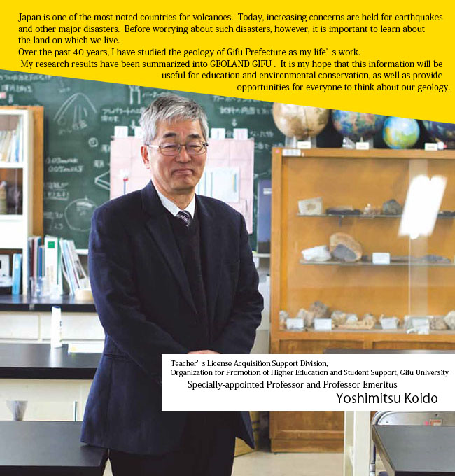
I became interested in the natural activities of earth, especially the dynamic activities of volcanos, when I was a college student, and I have been studying them ever since. When we think of volcanoes, the first ones that come to our minds are Mt. Ontake and Mt. Aso. What I study, however, is a rock mass called Nohi Rhyolite, which was formed about 70 million years ago as a result of volcanic activities. This mass extends over roughly a quarter of the entire Gifu prefectural area. In terms of the distribution area and its scale, it is one of the most distinguished rock masses of its period in Japan. I have devoted nearly 40 years of my life researching this gigantic rock mass.
My research was not done at my desk. I travelled to mountains and valleys throughout Gifu Prefecture. I brought back rocks from each place I visited, analyzed them, turned them into data and created geological maps, showing what rocks from which periods populate the prefecture. It is my conviction, however, that continual research alone is not meaningful. It must somehow contribute to society.

rocks and formations are distributed throughout the
prefecture of Gifu can be viewed at the GEOLAND GIFU
website. The map shown is the Gifu Prefecture Geological
Summary Map, which roughly segments with color the
area of Gifu according to the time each type of rock
and formation was created.
▶ http://www.geo-gifu.org/geoland/
This is why I constructed and released GEOLAND GIFU, which is a collection of Web-based geological map of Gifu Prefecture, so as to enable anyone to instantly access information on the geological formations and structures of Gifu and apply it for disaster prevention, environmental conservation and education.
Learning about the earth beneath us is essential before panicking about natural disasters

Compared with the rest of Japan, Gifu Prefecture covers an expansive area, with an elevation range that spans more than 3,000 meters. Its land contains diverse formations, some from very ancient times to others that were created in more recent history. There is no other prefecture that has geological features such as those found in Gifu. GEOLAND GIFU summarizes this complex geology into 1:50,000 scale maps, a wealth of detail that is a rarity in Japan. In addition to detailed geological maps of the entire prefecture, the site provides explanations on individual formations, as well as geological phenomena such as active faults, limestone caves and scenic sites. Around 370 items are explained in total.
At the heart of GEOLAND GIFU's creation is the wish to communicate to as many people as possible that nature should not be taken lightly. We do not pay much attention to the ground beneath us as we go about our day to day lives. Should it collapse, however, our lives will be endangered. Nonetheless, earthquakes, volcanic eruptions and tsunamis are all ordinary events as natural phenomena go. Before preparing for disasters, I would like everyone to first learn about the ground beneath our feet. In this light, I would very much like GEOLAND GIFU to be used by educational institutions as a teaching resource to give education to protect people's lives. And just as with these phenomena of natural disasters, I would like GEOLAND GIFU to be the tool to prompt visitors to hot springs and scenic sites to ask themselves why these geological features are the way they are instead of just being amazed.

mass. It stretches over an expansive area,
starting near Mt.Ena in the southeast corner of
Gifu Prefecture and extending to near Shirakawa
Village in the northwest corner of the prefecture.
In order to let as many people as possible know that GEOLAND GIFU can be used in such a way, we are planning to link together various data that have been accumulated, and create a sample tour route to encourage people to go out and visit sites. For instance, we may create Geo Rail, which will show observation spots to see formations as visitors ride the train to various areas. We hope to build the website into something that can be viewed with ease and used effectively. What I would like to communicate is that it is important for anyone, regardless of his or her age, to know the ground on which they live.